


sortie 20x05x25

Didier-114
User
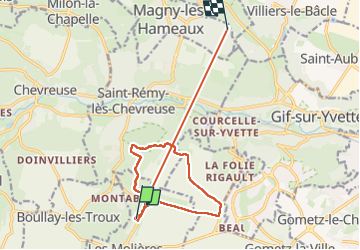

Length
14.4 km

Max alt
178 m

Uphill gradient
192 m
Km-Effort
16.9 km

Min alt
72 m

Downhill gradient
194 m
Boucle
No
Creation date :
2025-05-20 11:49:03.532
Updated on :
2025-05-20 14:47:43.87
2h34
Difficulty : Medium

FREE GPS app for hiking
 SityTrail
IGN / Geographical institutes
SityTrail Plus
The world is yours!
About
Trail Walking of 14.4 km to be discovered at Ile-de-France, Essonne, Les Molières. This trail is proposed by Didier-114.
Positioning
Country:
France
Region :
Ile-de-France
Department/Province :
Essonne
Municipality :
Les Molières
Location:
Unknown
Start:(Dec)
Start:(UTM)
431714 ; 5392163 (31U) N.
Comments